
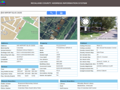
Richland County IT/GIS has published a new application which will provide information specific to an address including political districts, assessment information, and proximity to public amenities. This application will replace the current "DistrictInfo" application in early 2013 which will be available for use at http://www3.richlandmaps.com/districtinfo/ during the transition. Please visit the new GeoInfo application by clicking here or via the quicklink on the right side of the page. Feedback/comments are welcome via GIS@rcgov.us.
http://www2.richlandmaps.com/geoinfo/index.html
http://www.richlandmaps.com/apps/addsearch
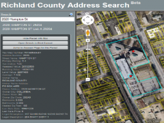
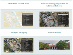
Use our newest application to view property information both on the map (standard map, aerial photos, oblique imagery, and Google street view are all available) and in tabular format.
http://www.richlandmaps.com/apps/gmap
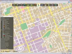
Richland County IT/GIS is excited to announce our newest application: an updated online map!
Richland County's most popular and useful layers are now viewable in the Google Maps environment. This is in addition to the ever growing number of layers that Google maintains and embeds within their maps. For the viewer this will mean increased speed and viewing flexibility.
This new mapping application is also mobile-friendly, so in addition to your desktop you can view map layers on your tablet or phone.
http://www3.richlandmaps.com/rcgeoportal/
This can be used to customize a map for your area of interest within Richland County with improved cartographic properties and performance. Using the display tools, you can locate an address or parcel number, zoom in on your area of interest, turn on/off over 100 layers, and print maps from your own computer. (IE7+, Firefox 3.0+, Chrome 3.0+, or Safari 4.0+ currently supported) For an online introduction to the Richland County Internet Mapping Service, Click Here.